Corporate Training Program
Customized geospatial technology training for organizations and working professionals — delivered in-person at NIGMT’s campus, online, or in hybrid mode. GIS, Remote Sensing, LiDAR, Photogrammetry & Surveying. Industry-experienced trainers. Flexible scheduling.

Overview
For Working Professionals & Organizations
Program Overview:
Our Corporate Training Program is specially designed for working professionals, government departments, PSUs, and private organizations seeking to upgrade technical expertise in Geospatial Technologies. The training is practical, customized, and aligned with real industry requirements.
What is the NIGMT Corporate Training Program?
Unlike standard courses, our Corporate Training Program is built around your organization’s specific needs. We consult with your technical leads, assess your team’s current skill levels, and design a curriculum that directly addresses your operational gaps — delivered at your premises, online, or in a blended format.
Who Designs the Training?
All corporate programs are designed and delivered by NIGMT’s industry-experienced, certified geospatial trainers — professionals with hands-on experience in government mapping projects, infrastructure surveys, agricultural applications, and defence geospatial work.
How It Works — 4-Step Process
| Step | What Happens |
|---|---|
| 🔍 Step 1 — Needs Assessment | We consult with your team to understand current skill levels, tools used, and training objectives |
| 📋 Step 2 — Custom Curriculum Design | We design a tailored training plan — topics, duration, depth, and delivery mode |
| 🎓 Step 3 — Training Delivery | Hands-on sessions delivered on-site / online / hybrid by certified trainers |
| 📜 Step 4 — Assessment & Certification | Skill assessment conducted, Corporate Certificates issued to all participants |
Training Delivery Modes
| Mode | Details |
|---|---|
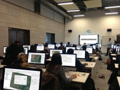
| 🏢 In-Person (On Campus) | Attend classes at NIGMT Foundation’s institute — hands-on practical training in our fully equipped geospatial lab with industry-standard software and hardware |
| 💻 Online / LMS | Live interactive sessions via video conferencing — recorded for team reference |
| 🔀 Hybrid | Combination of Offline and online sessions for maximum flexibility |
| 📅 Flexible Scheduling | Evening sessions, or intensive short-term workshops available |
🔹 Program Highlights:
- Customized Curriculum Based on Organizational Needs
- Advanced Training in GIS, Remote Sensing, LiDAR, Photogrammetry & Surveying
- Hands-on Practical Sessions with Real-Time Data
- On-site / Online / Hybrid Training Modes
- Industry-Experienced Certified Trainers
- Flexible Scheduling for Working Professionals
- Corporate Certification & Skill Assessment
- Fees and duration will be finalized after discussion or based on the candidate’s specific requirements.
Who Is This For
Organizations:
- Government Departments (Survey of India, Forest Dept, Revenue Dept, Municipal Corporations)
- Public Sector Undertakings (ONGC, NTPC, AAI, NHAI, Railways)
- Infrastructure & Construction Companies
- Agriculture & Environmental Agencies
- Defence & Security Organizations
- Smart City Project Teams
- NGOs & Research Institutions
- GIS & Remote Sensing Consulting Firms
Individuals / Professionals:
- Engineers (Civil, Environmental, Mining)
- Urban & Regional Planners
- Survey & Cadastral Professionals
- Remote Sensing Researchers
- Drone Operators seeking data processing skills
- IT professionals moving into Geospatial domain
Why Choose NIGMT for Corporate Training
Factor NIGMT Advantage Experience 7+ years of geospatial training expertise Trainers Active industry professionals, not just academics Flexibility Any duration — 1 day workshop to 3 month program Training Venue All in-person training conducted at NIGMT Foundation’s campus — fully equipped geospatial lab, industry-standard software, dedicated practical workstations Certification Industry-recognized Corporate Certificate issued Support Post-training technical helpdesk support Reach Pan-India training delivery capability
📍 Ideal For: Working professionals, engineers, planners, surveyors, researchers, and technical teams who want to upgrade their skills, improve productivity, and stay competitive in the evolving geospatial industry.
Course Features
- Activities Professtional Certification Program
Instructor
You May Like

1 Week Certification in Drone DGCA Certification
Get DGCA-ready in 1 week — drone regulations, airspace rules, safety protocols, and pilot fundamentals. India's legal framework for professional drone operations. 10th pass eligible.
- Days of Week: Monday to Friday

1 Month Certification Program in Drone Data Processing
Master drone data processing in 1 month — orthomosaics, DEMs, point clouds, 3D models, and GIS integration. 70–80% practical training, flexible mode, industry-standard software.
- Days of Week: Monday to Friday

3 Months Certification Program in (Advance GIS+ Python)
Master Advanced GIS & Python programming in 90 days — spatial automation, geospatial scripting, live project training, 100% placement assistance.
- Time: Daily Three Hours
- Days of Week: Monday to Friday

3 Months Certification Program in (GIS & Drone Advance Program)
Master GIS & Advanced Drone Technology in 90 days — UAV operations, drone data processing, live project training, 100% placement assistance.
- Time: Daily Three Hours
- Days of Week: Monday to Friday
🎓 M.Sc in Geoinformatics (1 Year – Lateral Entry)
(GIS & Remote Sensing Technology) 📍 Eligibility: Candidates who have completed a Diploma in Geoinformatics can apply. In-depth learning of modern geospatial technologies 80–85% focus...

Course Features
- Lecture 0
- Quiz 0
- Duration Lifetime access
- Skill level Intermediate
- Language English
- Students 0
- Assessments Yes